
Walk a Wilmette Street by Address
A sound Wilmette street directory search separates ownership from occupancy. Start with the Cook County parcel record because its PIN, the 14-digit property index number, follows the land more reliably than a typed street label. Then map nearby parcels, inspect recorded instruments, and add dated local sources. A deed names parties to a transfer, not every person in the home. Likewise, an old directory entry shows what its publisher recorded in that year.
- Enter the house number, street name, and Wilmette in the Cook County Assessor address search. Save the PIN and exact property-location text.
- Open CookViewer, locate that PIN, and click parcels along the desired street segment.
- Compare the parcel card with the Property Tax Portal for valuation, exemption, tax, and PIN-lineage clues.
- Run each PIN in the Clerk's Recordings System, then follow grantor and grantee names backward through deeds.
- For earlier residents, consult Wilmette Public Library and History Museum reverse directories, maps, permits, and house files.
This chain produces a dated record trail. Keep a source and retrieval date beside every name so a current parcel owner is never blended with a person listed decades ago.
Wilmette Street Directory Search Fields
The Assessor's basic form has no general public owner-name field. Address mode is therefore central to the Wilmette street directory. The form instructs users to omit words such as Avenue, Street, or Place from the street-name box. If a unit does not return a result, test the building address before deciding that no parcel exists.
| Field | Input | Street-use note |
|---|---|---|
| PIN number | 14 digits and CAPTCHA | Best link between assessor, tax, map, and deed sources |
| House Number | Required in address mode | Test the current number and a documented old number |
| Direction | Optional dropdown | Use when it forms part of the official address |
| Unit Number | Optional text | A unit result is not a household roster |
| Street Name | Required text | Leave off the street-type suffix as the form directs |
| City | Required text | Use Wilmette, then check postal and municipal geography |
Neighborhood, township, property class, address range, and partial-PIN controls appear in broader Assessor modes. They can narrow difficult records, but the public interface did not expose a whole-street owner export.
Browse Wilmette Streets in CookViewer
CookViewer turns a typed address into a map of parcel shapes. Search by property address, a 10- or 14-digit PIN, a dashed PIN, or a street intersection. The Select Tool can capture one parcel, several parcels, a rectangle, or a polygon. Results may be exported as CSV or Excel, while map and report controls can produce PDF output. Historical parcels and imagery add context when a modern lot does not match an old map.
The official CookViewer parcel map shows the screen used to start that geographic check.
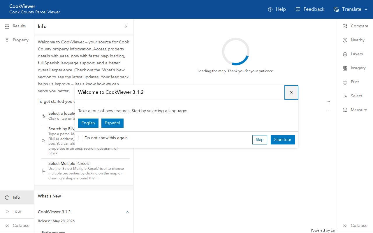
Use the map to define the parcel set, then return each PIN to the Assessor, tax, and deed systems. The map itself does not prove who occupies a home. Cook County launched CookViewer 3.1 in 2025 with improved mobile use, parcel symbols, measure tools, a guided tour, and PDF reports.
Note: Alleys, rail corridors, corner lots, and condominium common parcels can change which shapes truly belong to one Wilmette block.
Wilmette Records Indexed by Street
No single Wilmette street directory combines every address-bearing source. Each custodian records a different relationship to the property, and access ranges from a free portal to an appointment or records request.
| Address source | Keeper | What it can establish | Access channel |
|---|---|---|---|
| Parcel card | Cook County Assessor | PIN, situs location, class, characteristics, value, exemptions | Online address/PIN search or assessor data request |
| Parcel geography | Cook County GIS | Lot shape, nearby parcels, historic imagery, map context | CookViewer, export, printed report |
| Recorded instruments | Cook County Clerk | Deeds, mortgages, liens, plats, parties, dates | CRS index, paid images, Clerk counter, archive |
| Permits and zoning | Wilmette Community Development | Construction, demolition, occupancy, applicant or owner context | Department request, Village archive, Illinois FOIA |
| Historical occupants | WPL and WHM | Dated names, spouse, occupation, phone, address | Online indexes, Local History Room appointment, museum staff |
| Voter confirmation | Illinois elections authorities | One supplied person's registration match | Name, birth date, ZIP, then exact street verification |
Village records can be requested through Wilmette's FOIA route. Ordinary Illinois FOIA requests generally receive a response within five business days, subject to statutory extensions and other rules. Ask Community Development for a specific address file rather than a vague resident list.
Four Wilmette Address Terms
Address records become much easier to compare when their labels stay distinct. These terms describe land, delivery, and recorded roles, not interchangeable versions of one fact.
- Parcel
- A mapped tract of land identified in Cook County by a PIN. A building or condominium may involve more than one parcel.
- Situs address
- The property's physical-location label. The Assessor warns that Property Location is an office locator, not a legal or postal mailing address.
- Plat
- A recorded drawing that lays out lots, blocks, streets, or a subdivision. It can connect an old lot description to today's map.
- Criss-cross directory
- A directory arranged by street and house number so a researcher can move from an address to a dated occupant or subscriber.
A mailing address is where correspondence goes. A legal description uses subdivision, lot, block, section, township, range, or other land language. Either may differ from the situs line shown on a parcel card.
Follow Wilmette Deeds Along a Street
After collecting PINs from the map, search the CRS advanced deed index in a consistent date range. Useful modes include PIN, document number, grantor or grantee, document type, subdivision, and legal description. A grantor transfers an interest; a grantee receives it. Record the document number, recording date, type, names, legal description, and related PIN.
The advanced-search screen pictured below is the official source for a Wilmette by-address deed search.
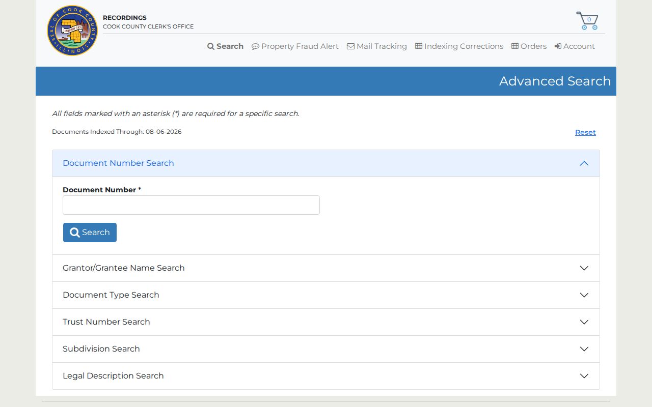
Begin with the latest deed, then search that grantor as an earlier grantee. Filter by document type because common surnames, lenders, trusts, and title companies create noise. The Clerk describes online searching from 1985 forward, while the live portal displayed documents indexed through August 6, 2026 when research was completed. Those dates describe different ends of the system.
Index cutoff. A blank online result is not proof that no deed exists. Use the Clerk's downtown counter or archive for older and excluded material.
Reverse Old Wilmette Street Directories
For the occupant layer, leave modern parcel tools and work with a dated reverse index. Wilmette History Museum identifies reversed sections for 1917–18, 1922–23, 1925, and 1935. It also created searchable reversed versions of its 1890, 1898, 1908, and 1946 street directories. Wilmette Public Library holds further Polk, North Shore, telephone, ownership, and house-history material.
The 1908 index shows why exact transcription matters. It separates house number and street, but some rows use a house number of 0 or railroad-style wording such as W R R Ave. One occupation preserves “Carpneter (Sic).” Search the error as printed, then try a likely spelling. Historical records may list spouses, servants, or separate family members, yet omit others.
Readers who need the full shelf, year runs, and entry abbreviations can use the Wilmette city directory collections. For street work, the key is to date the entry and preserve its original address text.
Wilmette Streets Cross Old Boundaries
Modern Wilmette contains older geographic labels. Gross Point incorporated in 1874, then Wilmette annexed it in parts in 1924 and 1926. No Man's Land retained a separate identity until annexation in 1942. An older directory, church item, permit, or newspaper may therefore file the same place under Gross Point, New Trier Township, or a landmark rather than modern Wilmette.
The library's map inventory supplies the crosswalk: original plats and Gross Point material from 1869–1874, additions and annexations from 1883–1911, Ouilmette reservation and subdivision maps from 1829–1842, and an 1850 New Trier Township map. Indian Hill Estates was platted in 1926. Ridge Road, Green Bay Road, Sheridan Road, rail lines, and cross streets can help align an old description.
No official source in the research established one village-wide street-renumbering year. Do not invent one. Bridge an old number with the legal description, parcel shape, maps, directory variants, ownership index, and newspaper references.
Check Wilmette Street and ZIP Labels
Official anchors confirm 60091 for Wilmette, including Village Hall, the library, the museum, and the Wilmette Post Office. Nearby Winnetka's post office uses 60093. That contrast is useful because ZIP codes describe postal delivery, while village limits describe municipal jurisdiction. A mailing city can also differ from the parcel's taxing or municipal geography.
Use the USPS ZIP Code Lookup with a complete address and unit. USPS can standardize the address and return ZIP or ZIP+4, but expressly does not confirm that a named person or company is present. Then compare the result with CookViewer and Village map sources.
Note: Treat 60091 as the verified Wilmette ZIP, but test every edge address instead of assigning municipal status from ZIP alone.
Wilmette Permits Fill Address Gaps
Wilmette Community Development holds building-permit material from 1920 forward according to the library's house-history guidance. Permit and occupancy files can add construction, demolition, remodeling, inspection, applicant, owner, architect, or contractor context. They still do not establish every resident at the address.
Start with the Community Development office and the Village Archive Center's dated categories. If no static result is online, request the specific address, permit type, and date span by department or FOIA. WPL house binders, architectural inventories for East Wilmette, Gross Point, and Indian Hills, plus annual January real-estate issues from 1935–40, can bridge gaps before the online deed era.
A strong street directory record notes whether a name came from a deed, permit, parcel card, directory, or public meeting file. Merely appearing in an address-linked document is not the same as residing there.
Limits of Wilmette Street Records
Parcel and deed records are designed to document land, value, and recorded interests. They do not reliably identify renters, children, visitors, or other non-owner household members. Utility customer lists and private association rosters were not found as open Wilmette datasets. Illinois driver-address data is restricted, and protected records may use substitute or redacted addresses.
The Illinois voter lookup is also not a street browser. It verifies one supplied person after name, birth date, five-digit ZIP, street number, and street name steps. Bulk voter data has eligibility, purpose, fee, redaction, and use limits. A historical directory may omit an unlisted subscriber or retain a dated name long after a move.
Lawful use. Use Wilmette address records for legitimate personal, family, property, or civic research. Never use them to stalk, harass, threaten, or harm anyone.
When the goal changes from a whole street to one named person, use the focused Wilmette resident lookup. In every case, verify a result with the office or collection that created it.